1.Shenzhen Magic Cube Satellite Technology Co., LTD
Shenzhen Magic Cube Satellite Technology Co., LTD., a national-level "Specialized, Refined, Distinctive and Innovative" small and medium-sized enterprise, is committed to creating satellites that everyone can afford. It is dedicated to the full-platform, high-quality and batch research and development of core products for microsatellites. The company is committed to the research and development of core single-machine products and system design for high cost-performance commercial satellites, and is dedicated to creating high cost-performance remote sensing satellite systems, ultimately achieving consumer-level commercial applications of satellite data.
The core members of the Magic Cube satellite all have nearly 10 years of experience in the aerospace industry and have been responsible for and managed the argumentation, manufacturing, management and operation of more than ten satellites. Familiar with the technical standards, industry norms and design, production and manufacturing processes of the aerospace industry, and possessing full industrial chain technical personnel specializing in satellite engineering (structural mechanics, attitude and orbit control, satellite service computer, thermal control, data transmission payload, overall circuit), constellation construction, satellite tracking and control, satellite application services, etc., with rich experience in design and production.
The single-machine products of Magic Cube Satellite are positioned as high quality, low cost, fast response and modularization. Under the premise of ensuring the high reliability requirements of the products, it minimizes costs to the greatest extent, shortens the production cycle, and meets the market demands of commercial microsatellite systems. The Magic Cube Satellite not only has the capability to develop core single-machine products across all platforms, but also possesses the design, production and operation capabilities of the entire satellite. By creating cost-effective microsatellite systems, we aim to drive the development of the satellite application market, ultimately achieve consumer-level commercial applications of satellite data, build a new aerospace business model dominated by applications, and effectively serve a large number of small and medium-sized enterprises and consumer-level users. The company is responsible for the development of multiple commercial constellations. As of October 2024, it has completed the in-orbit delivery of 24 satellites of two models. The company has been honored with titles such as "Specialized, Refined, Unique and Innovative", "High-tech Enterprise", and "Little Giant", and holds qualifications such as the second-level confidentiality qualification, the production qualification for weapons and equipment, and the second-level surveying and mapping qualification.
2. Introduction to the Company's Self-Developed SAR Satellite Project
The company, in combination with the existing constellation construction projects, realizes the construction of satellite constellations and provides services to end users through satellite data. The project not only conforms to the development direction of the local geographic information industry, but also can drive the establishment of satellite payload and platform component manufacturing enterprises in the local area through this project, promoting the aggregation of the entire industrial chain of satellite components, complete satellite manufacturing and satellite applications.
SAR (Synthetic Aperture Radar), namely Synthetic Aperture Radar, is an active earth observation system that can conduct observations of the Earth at all times and in all weather conditions and has the ability of high-precision deformation measurement. The SAR satellite system has unique advantages in applications such as disaster monitoring, environmental monitoring, Marine monitoring, resource exploration, surveying and mapping, and military affairs. Especially, it has very important practical significance for improving the comprehensive governance capacity of mining areas. Deformation monitoring technology based on SAR satellites can provide a more precise and extensive monitoring method for urban safety monitoring. It can offer valuable predictive capabilities for the entire mining process, verify the expected deformation, and accurately locate the subsidence area.
Compared with the traditional single monitoring, the accuracy and reliability have been significantly improved;
Regularly return monitoring information, reducing human input while making monitoring more timely and accurate.
Achieve comprehensive monitoring of cities and mining areas at the macro level and promote the construction of smart cities and smart mines.
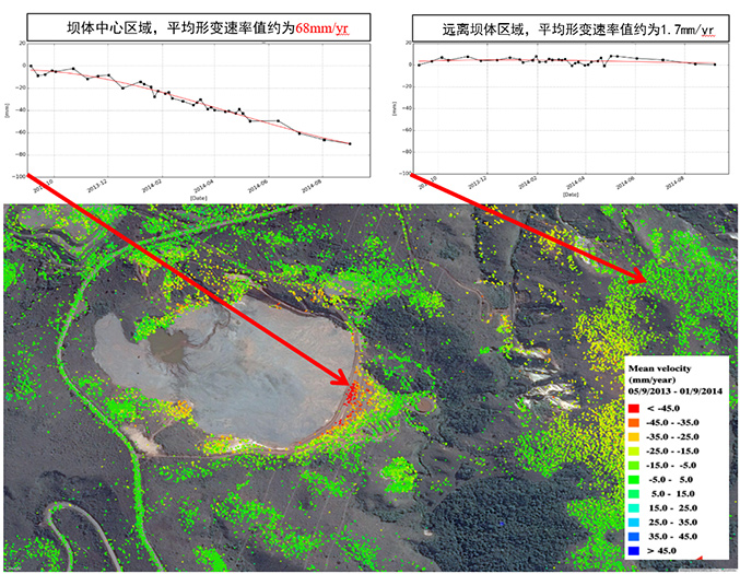
Analysis and Monitoring of Tailings Dam Collapse in Brazil
The company plans to build a SAR satellite constellation composed of 8 satellites. After the constellation project is completed, it will have the ability to conduct high-frequency revisits six times a day, millimeter-level deformation measurement, all-weather imaging, and comprehensive remote sensing application. It can ensure the availability of independent and controllable high-timeliness and high-reliability earth observation means, and will not be affected by external factors such as weather and war. Make up for the domestic commercial SAR gap and the insufficient supply of high-quality satellites.
3. Advantages of remote sensing technology services
Safety monitoring in different industries based on satellite remote sensing has the following advantages:
It can obtain a wide range of data and information. Satellite images can cover hundreds to thousands of square kilometers or more in one scene, and can simultaneously carry out synchronous monitoring tasks for a large area.
(2) The speed of obtaining information is fast and the cycle is short. As satellites orbit the Earth, they can obtain the latest information on various natural phenomena in the areas they pass through in a timely manner, so as to update the original data or conduct dynamic monitoring based on the changes of new and old data. This is incomparable to manual field measurement and aerial photogrammetry.
(3) The acquisition of information is less restricted by conditions. There are many places on the Earth with extremely harsh natural conditions that are difficult for humans to reach, such as deserts, swamps, and high mountains. By adopting remote sensing technologies that are not restricted by ground conditions, especially aerospace remote sensing, various valuable data can be obtained conveniently and promptly.
(4) SAR satellite imaging features all-weather and all-time characteristics, is an active remote sensing system, and can penetrate clouds and fog.
(5) The trend of integrated geological monitoring featuring multiple technologies, disciplines and monitoring methods is becoming increasingly evident. The development of modern monitoring technologies should be dedicated to achieving complementary advantages, information exchange and optimized integration among various technologies. Remote sensing technology can play an extremely important role in this process.
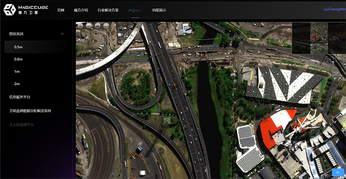
High-resolution satellite remote sensing images and platform display system
4. Introduction to Geological disaster and environmental Service Products Based on Satellite Remote Sensing
4.1 Ground object classification or change detection based on optical satellites
Content Introduction: Procure optical satellite images of the designated area, develop high-precision image segmentation, classification and change detection models related to satellite images, and extract the types of ground objects and change areas in the target area.
Monitoring frequency: 2 to 12 times per year. The monitoring frequency can be determined as needed.
Monitoring accuracy: 80% to 97% (related to image quality and image resolution).
Application scenarios: Monitoring of ongoing construction projects, monitoring of illegal construction, smart city base maps, digital farmland census, ecological red line monitoring, ecological index assessment, monitoring of the four disorders in rivers and lakes, forest resource monitoring, monitoring of mining area development progress, and monitoring of changes in the development ecological environment.
4.2 Deformation Monitoring and Deformation Anomaly Identification Based on InSAR Technology
Content Introduction: Purchase SAR satellite images of the designated area, design and select the appropriate deformation extraction algorithm for the target, extract the deformation monitoring results of the target area, and combine historical disaster points and abnormal area judgment models in different scenarios to extract the abnormal deformation areas in the measurement area.
Monitoring frequency: 4 to 18 times per year. The monitoring frequency can be determined as needed.
Deformation monitoring accuracy: 3 to 5mm/y.
Quotation reference (related to requirements such as monitoring resolution, frequency, and survey area. For the highest resolution time series monitoring, it is recommended to choose over 100 square kilometers.)
4.3 Assessment of the susceptibility to geological disasters in the survey area Based on Satellite remote sensing
Content Introduction: Procure or collect all the basic data required for the target area, process and extract various assessment indicators from the basic data, develop a susceptibility assessment model specifically for the mining area, combine various indicators with the susceptibility assessment model to extract the susceptibility assessment results of the target area, and classify the susceptibility risk levels based on the susceptibility assessment results.
Monitoring frequency: 1 to 4 times per year. The monitoring frequency can be determined as needed.
Monitoring accuracy: The probability of expected disaster points occurring in high-risk areas is greater than 80%.
4.4 Risk assessment of disaster points Based on InSAR technology and multi-source data fusion technology
Content Introduction: Procure or collect all the basic data required for the target area, process and extract various assessment indicators from the basic data, develop a risk assessment model specifically for the mining area, extract the risk assessment results of the target area by combining various indicators and the risk assessment model, and classify the risk levels based on the risk assessment results.
Monitoring frequency: 4 to 12 times per year. The monitoring frequency can be determined as needed.
Monitoring accuracy: The probability of expected disaster points occurring in high-risk areas is greater than 80%.
4.5 Customized services for Integrated space-ground tracking monitoring and early warning
Content Introduction: Obtain the risk level classification results of the mining area, install real-time tracking and monitoring equipment for meteorology and deformation in key areas, continuously input real-time monitoring data, risk level classification results and deformation monitoring results of SAR satellites in each period into the disaster early warning model, set early warning conditions in combination with disaster points and some rules, and release early warning information in a timely manner when disaster points trigger early warning conditions.
Monitoring frequency: 1 time per minute or 1 time per hour or 1 time per day. The monitoring frequency can be determined as needed.
4.6 Satellite "Sky Eye" atmospheric and water environment monitoring system services
Content Introduction: Obtain data from meteorological satellites and remote sensing satellites, and based on core algorithm inversion, analyze the indicators of the six elements of the atmospheric environment (SO2, NO2, PM10, PM2.5, CO, O3) in the designated area. Combined with meteorological wind field and ground sensor data, conduct pollutant tracking and source tracing, etc.
Monitoring frequency: 1 time per hour or 1 time per day/week/month. The monitoring frequency can be determined as needed.
4.7 Customized Development of Satellite Remote Sensing Big Data Monitoring Platform
Content Introduction: Build a big data monitoring system that combines satellite remote sensing, ground online monitoring and manual inspection and governance
The measurement platform is used to achieve all-round monitoring of the measurement area and its surrounding areas. The development of modules is carried out based on the service content selected by users. Among them, modules such as user management, data query, data storage, disaster point management, data display, and data statistical analysis are the basic modules.
4.8 Satellite stereoscopic image 3D modeling services
Content Introduction: By leveraging satellite stereoscopic imaging capabilities and integrating digital elevation models, etc., terrain-level three-dimensional models can be constructed and applied in scenarios such as digital city foundations, digital villages, and digital mines.
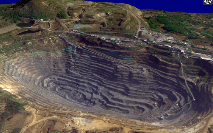
High-resolution satellite stereoscopic mine modeling and platform display system
4.9 Precise weather forecast Service
Content Introduction:
The AI meteorological large model utilizes deep learning to mine the relationships of meteorological elements with massive data and extract features based on specific network structures. In numerical forecasting, the Tianmu occultation data is integrated to extract the characteristics of typhoons. Combined with algorithms to predict the trajectories of typhoons, multiple factors are comprehensively optimized to predict the intensity and influence range of typhoons.
Monitoring accuracy: Traditional methods based on physical models are prone to accumulate errors. The Tianmu AI numerical prediction, which integrates Tianmu occultation data, can capture subtle changes and provide more accurate predictions of typhoon paths, etc.
Timeliness: Traditional forecasting involves a large amount of computation and is updated slowly. Tianmu AI numerical forecasting, by leveraging computing power and algorithms to process multi-source data, provides more timely meteorological information.
Resolution: The traditional forecast grid has a low resolution and is difficult to describe small-scale meteorological phenomena. The Tianmu AI numerical forecast that integrates Tianmu occultation data can significantly improve the spatial resolution and make more accurate local weather predictions.
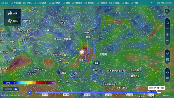
Global Meteorological wind field and Typhoon Path Prediction System